WELCOME TO TYPHOON AND WEATHER IMAGERY. THIS BLOG CONTAINS REAL TIME WEATHER, TROPICAL CYCLONE UPDATES AND IMAGERY, AND TROPICAL CYCLONE FORECAST. CONTENTS OF DROP DOWN MENU CAN BE FOUND AFTER PHILIPPINE IMAGERY BELOW (SCROLL DOWNWARD). THANK YOU VERY MUCH FOR VISITING THIS SITE. YOU ARE FREE TO MAKE ANY COMMENT(S) OR FEEDBACK(S) ABOUT THIS BLOG. MAY 29, 2025 - 10PM SYNOPSIS: Southwesterly Windflow affecting the western section of Luzon and Visayas.

ACTIVE LOW OR TROPICAL CYCLONES

CLICK IMAGERIES TO REDIRECT ON COMPLETE IMAGERIES AND INFORMATIONS (Imageries will be seen after Philippines imagery below)

WUTIP

LANGUAGE TRANSLATION

PHILIPPINES RADAR COURTESY OF RAINVIEWER THRU PAGASA DOPPLER RADAR


NCR DOPPLER RADAR

PHILIPPINES DOPPLER RADAR
RealEarth


TROPICAL CYCLONE YASI 11P SUMMARY 2011


TROPICAL CYCLONE YASI 11P (FOR LATEST POSITION, MOVEMENT AND INTENSITY)


CLICK IMAGERY TO SEE LOOPING IMAGERY

Multiplatform Tropical Cyclone MSLP and Maximum Winds


SUMMARY


MAXIMUM WIND: 135kt AND gust of 165kt
LOWEST PRESSURE: 922mb
ACE: 18.4725
DVORAK MAX WIND:140.0kt
DVORAK SEA LEVEL PRESSURE:900.0mb


JUST VOTE OR COMMENT FOR FEEDBACK

MJO WEAKENS, SUPPRESSED CONVECTION REACHES SE ASIA AND E ASIA


Above average rainfall continues to affect mostly the Eastern part of the country.
Enhance MJO weakens but remains along Maritime continent as Suppressed MJO reaches Southeast and East Asia.
Strong easterly wind continues to blow across Western Pacific.
Overall, rain still expected over Southern and Central Philippines at least within this week  


JUST VOTE OR COMMENT FOR FEEDBACK

TROPICAL CYCLONE BIANCA 10S SUMMARY 2011


TROPICAL CYCLONE BIANCA 10S SUMMARY 2011


CLICK IMAGERY TO SEE LOOPING IMAGERY

Multiplatform Tropical Cyclone MSLP and Maximum Winds


MAXIMUM WIND: 115kt AND gust of 140kt
LOWEST PRESSURE: 945mb
ACE: 9.27
DVORAK MAX WIND:87.4kt
DVORAK SEA LEVEL PRESSURE:954.9mb


JUST VOTE OR COMMENT FOR FEEDBACK

SUPPRESSED MJO NEARS PHILIPPINES, LESS RAIN EXPECTED


Suppressed phase of MJO slowly moving towards Asia and expected to reach Philippines by the end of the Month and stays til first week of February
This will give drier air along our atmosphere for the next 2-3 weeks but next week rain still continues as MJO still reaches Southern part of our country.
JUST VOTE OR COMMENT FOR FEEDBACK

TROPICAL CYCLONE ANTHONY 09P SUMMARY 2011


TROPICAL CYCLONE ANTHONY 09P SUMMARY 2011


CLICK IMAGERY TO SEE LOOPING IMAGERY

Multiplatform Tropical Cyclone MSLP and Maximum Winds


MAXIMUM WIND: 45kt AND gust of 55kt
LOWEST PRESSURE: 988mb
ACE: 1.86
DVORAK MAX WIND:57.0kt
DVORAK SEA LEVEL PRESSURE:983.9mb


JUST VOTE OR COMMENT FOR FEEDBACK

2011 FORECAST, WETTEST WEATHER AND MORE TROPICAL CYCLONE EXPECTED OVER PHILIPPINES

Disaster prone Philippines expected to face another wave of catastrophe if most of us wont be prepared. Current conditioning of both waters (South China sea and Philippines sea) triggering unseasonal weather such as stronger and longer thunderstorms, excess rainfall over most of the country, on and off cold and warm weather. Here are the current conditions, and possible climate conditioning that our country will have in the coming months including typhoon seasons.


List of Figures


SEA LEVEL PRESSURE
CIRCULATION
COLD PIXEL (CONVECTION)
SHEAR
INSTABILITY


MOISTURE


DIVERGENCE
EQUATORIAL TEMPERATURE/THERMOCLINE


OUTGOING LONGWAVE RADIATION
SOI
150 M DEPTH

  • 2010-11 la nina is considered as one of the strongest and ranked number two between 1917-18, 1975-76, 1988-89 and 1998-2000.
  • -1.4C as of October-December anomalies.
  • Southern Oscillation Index (SOI) remains strongly positive at +26.2 during this month (January). SOI since april of 2010 were consistently positive. December 2010 SOI at +27.1, the strongest since June 1950 SOI of +26.9.
  • 150m Depth-average temperature anomaly (see figure above) shows higher at +4.0C observe along Western Pacific (130-140E) while lower at -4.6C over Eastern and Central Pacific.
  • Thermocline (Depth at which the rate of decrease of temperature with increase of depth is the largest) indicates (see figure above) a +4.5C high anomalies over Western Pacific with cooler at -5.1C over Central Pacific.
  • OLR (Outgoing longwave radiation) were negative over Philippines and Maritime continent, indicating that enhance rainfall persisted over the area.

Time Series along 100-150N (WESTERN PAC II: 100-120N/SOUTH CHINA SEA, WESTERN PAC III: 120-150N/PHILIPPINE SEA)

  • 850hpa Circulation: Above average over near western Philippines as near normal over the other side.
  • Sustained convection: Above average over both side of western pac II and III.
  • Vertical Shear: Below average over Western pac II as above average over III.
  • Instability: Above average over western Pacific II (produces more enhance thunderstorm) as below to near average over the other side.
  • Moisture over Mid and upper level: Well above average over Both side.
  • Horizontal divergence: near normal over South China sea as Above to near normal average over Philippine sea.
  • Surface Pressure: Lower surface Pressure over Both side.

FUTURE FORECAST

  • Monsoon break expected within the next 2-3 weeks after series of incessant rain over Philippines that resulted to flooding in different parts.
  • Warmer SST over Philippine sea expected to pump more moisture over the country.
  • This allow some convective formations linger each time frontal system appears.
  • February to mid- march is expected to be warmer with some instance of rainshower and/or thunderstorms in other area.
  • Mid- march to April, possible early transition towards rainy season as solar heating (due to longer day and shorter night) expected to pump more moisture over Philippines atmosphere and perhaps saturates quickly as mid- and upper level are completely saturated if current condition considered.
  • This considers the early arrival of pre-summer thunderstorms.
  • Tropical cyclone formations are possible during summer months (February-April).
  • Possible stronger Rainrate during southwest monsoon as lifespan of every convections to develop will be longer during the said period.
  • F0-F1 tornadoes also possible during rainy season (2008-09 moderate la-nina triggered series of tornadoes that touched down during strong monsoonal weather).

SUMMARY

Wet summer season is expected this year considering the current conditions mentioned above. This year is going to be the wettest since the last strong la-nina (1988-89). SOI index becomes strongest at +27.1, (Sustained positive SOI are associated with stronger trade winds and warmer than normal SST north of Australia, also known as La-nina episode while Sustained negative SOI are known to be El-nino episode) which resulted to flooding over Queensland, Brisbane due to above rainfall.
More strong to intense thunderstorms that might results to hail and even tornadoes expected mostly during pre-monsoon season.
Typhoon season on the other hand will become active after a record breaking last year of few tropical cyclone formation (14 named tropical cyclones).
Number of Tropical cyclone usually grew more in numbers mostly during la-nina and post la-nina
Chances of more tropical cyclones expected to hit land are good during early season (may-june) coming from South china sea.
During October-December, based on other la-nina years, most strong tropical cyclones developing and eventually most of them hitting land over Southern and Central Luzon including Bicol down to Visayas.


JUST VOTE OR COMMENT FOR FEEDBACK

TROPICAL CYCLONE WILMA 08P 2011


TROPICAL CYCLONE WILMA 08P SUMMARY 2011


CLICK IMAGERY TO SEE LOOPING IMAGERY

Multiplatform Tropical Cyclone MSLP and Maximum Winds


MAXIMUM WIND: 115kt AND gust of 140kt
LOWEST PRESSURE: 930mb
ACE: 16.5075
DVORAK MAX WIND:119.8kt
DVORAK SEA LEVEL PRESSURE:922.0mb


JUST VOTE OR COMMENT FOR FEEDBACK

VORTICITY OVER PHILIPPINES INCREASES AS MID AND UPPER MOISTURE STILL ABUNDANT


  • Mid and upper level moisture remains abundant over Philippines
  • Enhance to very enhance convection remain well develop over South China sea
  • Strong vorticity intensifying over Eastern part of Luzon
  • Almost closed weak circulation over the area of strong vorticity
  • Overall, possible development of tropical disturbance over the area
  • Enhance to very enhance rainfall expected to continue atleast for the next 3 days
JUST VOTE OR COMMENT FOR FEEDBACK

MJO CAUSED 3 TROPICAL CYCLONE OVER SOUTHERN PACIFIC


  • Very enhance MJO over Northern Australia, cause multiple tropical cyclone named 05P, 06S, and 07P
  • Evident are the stronger Westerly wind over the area
  • Quite Enhance MJO remains affecting Mindanao
  • Overall, Rainfall remains enhance over Philippines with very enhance to strong rainfall over Australia and Maritime continent.
JUST VOTE OR COMMENT FOR FEEDBACK

TROPICAL CYCLONE ZELIA SUMMARY 2011


TROPICAL CYCLONE ZELIA 07P 2011 SUMMARY


CLICK IMAGERY TO SEE LOOPING IMAGERY

Multiplatform Tropical Cyclone MSLP and Maximum Winds


MAXIMUM WIND: 90kt AND gust of 110kt
LOWEST PRESSURE: 957mb
DVORAK MAX WIND:90kt
DVORAK SEA LEVEL PRESSURE:954.6mb


JUST VOTE OR COMMENT FOR FEEDBACK

ENHANCE TO VERY ENHANCE RAINFALL CONTINUES OVER THE COUNTRY


  • Moist to very moist air remains over Philippines
  • Strong la-nina easterly continues to prevail
  • Overall, Enhance to very enhance rainfall expected to continue mostly over eastern part of the country


JUST VOTE OR COMMENT FOR FEEDBACK

TROPICAL CYCLONE VINCE SUMMARY 2011


TROPICAL CYCLONE VINCE 06S 2011 SUMMARY


CLICK IMAGERY TO SEE LOOPING IMAGERY

Multiplatform Tropical Cyclone MSLP and Maximum Winds


MAXIMUM WIND: 40kt AND gust of 50kt
LOWEST PRESSURE: 986mb
DVORAK MAX WIND:45kt
DVORAK SEA LEVEL PRESSURE:991.0mb


JUST VOTE OR COMMENT FOR FEEDBACK

TROPICAL CYCLONE VANIA 2011 SUMMARY


TROPICAL CYCLONE VANIA 05P 2011 SUMMARY


CLICK IMAGERY TO SEE LOOPING IMAGERY

Multiplatform Tropical Cyclone MSLP and Maximum Winds


MAXIMUM WIND: 60kt AND gust of 75kt
LOWEST PRESSURE: 970mb
DVORAK MAX WIND:59kt
DVORAK SEA LEVEL PRESSURE:980.8mb


JUST VOTE OR COMMENT FOR FEEDBACK

TROPICAL WAVE APPROACHES PHILIPPINES, COLD FRONT DIFFUSES

LATEST IMAGE AS OF JAN 08 2011


  • Tropical wave spotted far east of Eastern Visayas moving more WNW.
  • Cold front started to diffused.
  • MCS continues to survive over eastern Visayas.
  • Overall, moderate-strong thunderstorms still expected over Eastern Visayas.
  • Underwatch is the tropical wave mentioned as vorticity continues to increase for the past 6hrs.
  • Possibly to become a tropical disturbance is likely if intensification continues.


JUST VOTE OR COMMENT FOR FEEDBACK

RAIN EXPECTED TO CONTINUES AS ANOTHER COLD FRONT SET TO REACH PHILIPPINES BY SAT

CLICK IMAGERY TO SEE LEGEND


JUST VOTE OR COMMENT FOR FEEDBACK

DECEMBER 25 2010-JANUARY 5 2011 RAINFALL


This is the latest info regarding of possible amount of rainfall over Philippines.


JUST VOTE OR COMMENT FOR FEEDBACK

RAINFALL CONTINUES AS ENHANCE TO VERY ENHANCE MOIST EXTENDED OVER PHILIPPINES


  • Enhance MJO position over western maritime continent.
  • Evident are 16m/s windspeed (58kph) over western australia. 
  • Enhance to very enhance rainfall remain extending over Philippines.
  • Overall, enhance rainfall expected to continue over Philippines atleast for the next 2-3 days


JUST VOTE OR COMMENT FOR FEEDBACK
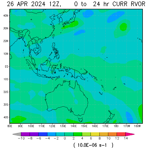
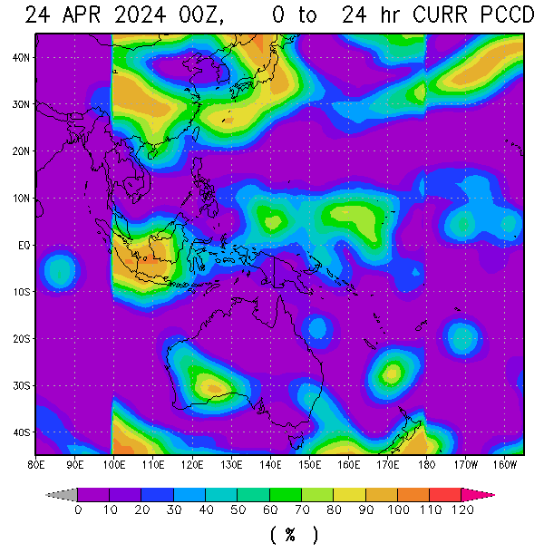
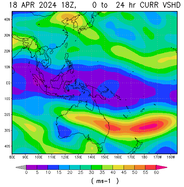
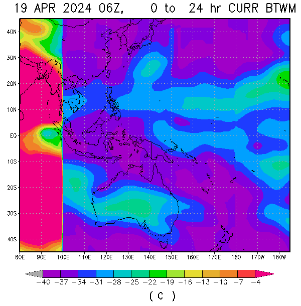
VORTICITY Percent Pixels Colder than -40°C 850-200 hPa Vertical Shear (kt) Cloud-cleared Water Vapor Brightness Temperature (°C)MSLP (hPa)

HIMAWARI WESTERN PACIFIC IR TEMPERATURE IMAGERY

MY TWEETER

News & Journalism - Top Blogs Philippines
Academics

GOOGLE SEARCH TOPIC

Top Stories - Google News

Blog Archive

REFRESH TO UPDATE