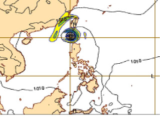
TYPHOON LUPIT (RAMIL/22W) IMAGERY
TYPHOON LUPIT (RAMIL/22W)
CATEGORY 2
LOCATION: 19.99N, 126.76E (475KM ESE BASCO, BATANES)
MSLP: 963MB
WINDSPEED: 80-100KT (148-185KPH)
MOVEMENT: WSW 9KT/17KPH
RAINRATE: +30MM/HR
CENTER TEMP.: (DVORAK): -64.33C (CENTER)
DEEPEST CONVECTION: HEAVY (-66.95C)
VORTICES: 250
NEXT 12HRS: 80-90KT/148-167KPH
DVORAK
MSLP : 967.08MB VMAX: 78KT/144KPH
DIFFERENT AGENCIES:
(JTWC): MSLP : 982.1MB VMAX: 59KT/109KPH
(RSMC): MSLP : 982.0MB VMAX: 59KT/109KPH
(CIMSS): MSLP : 978.8MB VMAX: 63KT/117KPH
(RAMMB-CIRA): 954.6MB VMAX: 92KT/170KPH
(AMSU): MSLP: 951MB VMAX: 102KT/189KPH
(SATCON): MSLP: 954MB VMAX: 92KT/170KPH
(MIMIC): VMAX: 80KT/148KPH
(PAGASA): VMAX: 175-210KPH
NOTE: Based on new forecast by ECMWF shows that lupit is most likely to spare Cagayan region by direct hit rather a possible weakness of high over north of it will eventually shift the system more westward towards Batanes-Taiwan area. However, stormy weather still expected over those areas over northern luzon by friday-saturday. It is more likely to weakens further as drier air entraping to its circulation.


No comments:
Post a Comment