ALL INFORMATIONS AND/OR DATA PUBLISHED ON THIS BLOG ARE SUPPORTED BY ALL WEATHER AGENCIES (SEE BELOW OF THIS BLOG). THIS WAS DONE FOR RECORDS AND USAGE FOR REAL TIME OBSERVATIONS RELEVANT TO TROPICAL CYCLONE INFORMATIONS AND WEATHER UPDATES. KINDLY REFER TO YOUR RESPECTIVE WEATHER AGENCIES FOR UP TO DATE INFORMATIONS. PLEASE REFRESH THIS BLOG TO HAVE AN UP TO DATE SATELLITE IMAGERY.
WELCOME TO TYPHOON AND WEATHER IMAGERY. THIS BLOG CONTAINS REAL TIME WEATHER, TROPICAL CYCLONE UPDATES AND IMAGERY, AND TROPICAL CYCLONE FORECAST. CONTENTS OF DROP DOWN MENU CAN BE FOUND AFTER PHILIPPINE IMAGERY BELOW (SCROLL DOWNWARD). THANK YOU VERY MUCH FOR VISITING THIS SITE. YOU ARE FREE TO MAKE ANY COMMENT(S) OR FEEDBACK(S) ABOUT THIS BLOG. MAY 28, 2026 - 1AM SYNOPSIS: Southwesterly Windflow affecting Palawan and the western section of Mindanao. Trough of Tropical Storm (TS) affecting the eastern section of Mindanao.
PHILIPPINES RADAR COURTESY OF RAINVIEWER THRU PAGASA DOPPLER RADAR
Post a Comment
REFRESH TO UPDATE
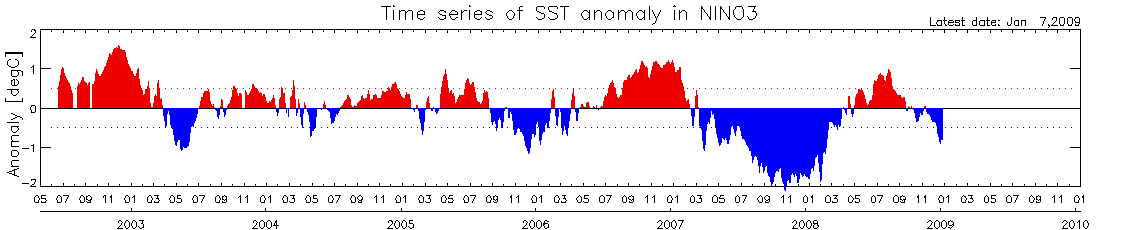 Based on SST anomalies shown above indicates further cooling process of Eastern equatorial pacific (kindly click for full viewing of image).
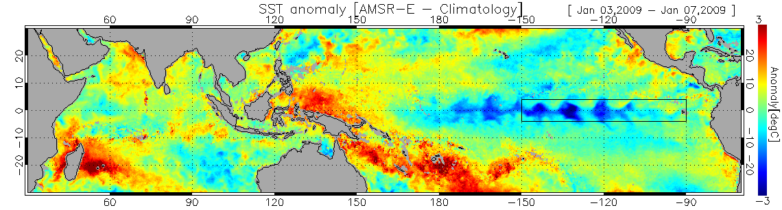 Images seen above shows cooler SST located between NINO 3,4 by -1.1 degree. (kindly click for full viewing of image). Upper-level (200-hPa) westerly wind anomalies continued over much of the equatorial Pacific. An anomalous cyclonic couplet is evident in the subtropics consistent with La Niña. For full report you may visit this site http://www.cpc.ncep.noaa.gov/products/analysis_monitoring/lanina/enso_evolution-status-fcsts-web.pdf


No comments:
Post a Comment