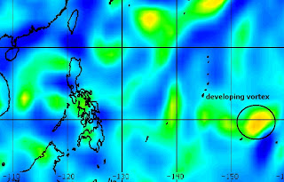
WELCOME TO TYPHOON AND WEATHER IMAGERY. THIS BLOG CONTAINS REAL TIME WEATHER, TROPICAL CYCLONE UPDATES AND IMAGERY, AND TROPICAL CYCLONE FORECAST. CONTENTS OF DROP DOWN MENU CAN BE FOUND AFTER PHILIPPINE IMAGERY BELOW (SCROLL DOWNWARD). THANK YOU VERY MUCH FOR VISITING THIS SITE. YOU ARE FREE TO MAKE ANY COMMENT(S) OR FEEDBACK(S) ABOUT THIS BLOG. As of 7PM MAY 3, 2024 - SYNOPSIS: WARM EASTERLIES OVER THE COUNTRY

ACTIVE LOW OR TROPICAL CYCLONES

CLICK IMAGERIES TO REDIRECT ON COMPLETE IMAGERIES AND INFORMATIONS (Imageries will be seen after Philippines imagery below)

91W INVEST

90W INVEST

LANGUAGE TRANSLATION

PHILIPPINES RADAR COURTESY OF RAINVIEWER THRU PAGASA DOPPLER RADAR


NCR DOPPLER RADAR

PHILIPPINES DOPPLER RADAR
RealEarth


2 TROPICAL CYCLONE LIKELY WITHIN THE NEXT 120 HRS

RELATIVE VORTICITY


NOGAPS 120 HRS FORECASTS


Tropical cyclone formations are expected within the next 5 days.
First tropical cyclone is possible on the next 48hrs over se portion of Guam.
Latest vorticity (sept 26) shows active vortex developing over SE of Guam.
Next 3-5 days shows 3 more likely to develop with one stalling over east of Philippines.
Overall, atleast 2 tropical cyclone expected within the next 5 days.


JUST VOTE OR COMMENT FOR FEEDBACK

No comments:

VORTICITY Percent Pixels Colder than -40°C 850-200 hPa Vertical Shear (kt) Cloud-cleared Water Vapor Brightness Temperature (°C)MSLP (hPa)

HIMAWARI WESTERN PACIFIC IR TEMPERATURE IMAGERY

MY TWEETER

News & Journalism - Top Blogs Philippines
Academics

GOOGLE SEARCH TOPIC

Top Stories - Google News

Blog Archive

REFRESH TO UPDATE