 It is early to predict as of this time whether this year, there will be more or less tropical cyclone to form and if how strong will be their intensity. But if we are going to consider the last 6 months (October 2008-March 2009), a more likely normal number of tropical cyclone is expected as Eastern Equatorial Pacific now back to Neutral condition, however the intensity remain optimistic as current condition of western pacific remain favourable for strong category of tropical cyclone depending on its latitudinal formation. As you can see on images from left, Sea height anomalies spread from Philippines sea toward marianas trench with deeper and warmer area compared to 2008.

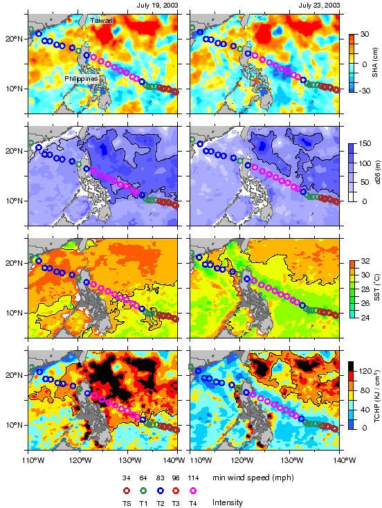
Although sea surface temperature varies a little, warmer water are observed near philippines coast with colder at near east of Guam. Depth 26 isotherm also shows a broader area of above 26C though not as warm as 2008 across the area. Example of the effect of this was typhoon Imbudo (http://www.aoml.noaa.gov/phod/dataphod1/work/HHP/VAL/IMBUDO/HHP_Imbudo.jpg) (http://www.aoml.noaa.gov/phod/dataphod1/work/HHP/imbudo.html). In this imagery shows a sudden intensification of Imbudo to a almost super typhoon as it moves to higher SST, OHC and SHA.
If this condition persist, a stronger tropical cyclone expected over 8-22N,126-138E as rapid deepening and drop of sea surface pressure likely as warmer and plenty of moisture expected over the area which is main ingredient for intensification of TC.

As observed, rainfall anomalies over the area near east of the Philippines shows above normal amount as convections along the area keeps developing due to high moisture content over the area.
Early onset of Rainy season may also be influences by this condition as possibly atleast 1 TC expected to develop within end of April or first week of May.


No comments:
Post a Comment