EL NINO ADVISORY
DEC 10 2009
Mature El Niño conditions continue to dominate the equatorial Pacific Ocean. Ocean surface temperatures in the central Pacific remain at levels not seen since the El Niño events of 2002-03 and 1997-98, with values more than 2°C above normal in places along the equator. Leading climate models continue to suggest tropical ocean temperatures will remain above El Niño thresholds into the new year, though most indicate the El Niño will decline after the southern hemisphere summer.# The tropical Pacific Ocean sea surface remains significantly warmer than the long-term average in central and eastern areas.
# The sub-surface water of the tropical Pacific remains warmer than the long-term average. The eastern Pacific has cooled slightly in the last two weeks.
# The latest approximate 30-day SOI value is −9; the monthly value for November was −7. The SOI increased in value in the second half of November, but is currently falling once again.
# Trade winds are close to normal across the central and eastern tropical Pacific. A strong westerly wind burst has weakened the Trades significantly in the western Pacific.
# Cloudiness near the date-line has increased over the past fortnight.
# Most leading international computer models surveyed by the Bureau predict that El Niño conditions will persist through the southern hemisphere summer, but decline thereafter
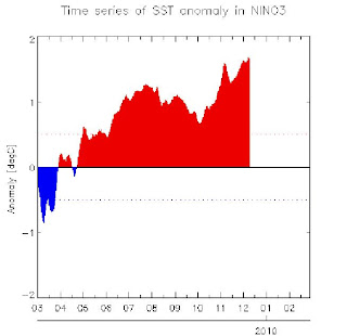
Sea surface temperatures (SSTs) across the tropical Pacific Ocean remained above normal for the month of November. The SST anomaly map for November is available here; the map shows warm anomalies in excess of +1°C covering most of the tropical Pacific east of 160°E, with anomalies exceeding +2°C in parts of the central Pacific. The map also shows near-normal SSTs covering most of the western Pacific and northern waters around Australia. The monthly NINO indices for November were +1.3°C, +1.7°C and +1.5°C for NINO3, NINO3.4 and NINO4 respectively. Each of the NINO regions has warmed when compared with October values; NINO3 by approximately 0.4°C, NINO3.4 by 0.6°C and NINO4 by 0.2°C.
In terms of weekly data, the most recent NINO indices are +1.5°C, +1.7°C and +1.3°C for NINO3, NINO3.4 and NINO4 respectively. When compared with two weeks ago NINO3 and NINO3.4 have risen slightly, while NINO4 has recorded a change of −0.3°C. The 7-day SST anomaly map shows warm anomalies in excess of +1°C covering most of the tropical Pacific east of the dateline. When compared with anomalies observed two weeks ago, there is little change in terms of sea surface temperatures. An animation of recent SST changes is available.
The sub-surface of the equatorial Pacific Ocean has cooled slightly in the last two weeks. However, the sub-surface still remains significantly warmer than the long-term mean and shows a clear El Niño pattern. A four-month sequence of Pacific Ocean equatorial temperature anomaly is available here. The sequence shows cooling of the sub-surface through August and September followed by a relatively rapid warming through October and November, particuarly in the eastern equatorial Pacific. A recent map for the 5 days ending 6 December shows a large volume of sub-surface water more than 2°C warmer than normal for this time of the year extending across much of the central to eastern equatorial Pacific. Warm anomalies in excess of 5°C are evident between 140°W and 100°W on a weekly scale. When compared with two weeks ago, the western and central sub-surface has cooled slightly. This is related to the return to normal Trade wind conditions. An animation of recent sub-surface changes is available.
An archive of past SST and sub-surface temperature charts is available.
Trade winds remain at relatively normal conditions across most of the tropical Pacific. A westerly wind burst has emerged in the western equatorial Pacific warming the underlying ocean. The latest weekly wind anomalies are shown in the TAO/TRITON map (small image above) for the five days ending 6 December.
The SOI increased through November, but has been decreasing again since the start of December. This follows the rapid fall in the value of the SOI during October. The latest (7 December) approximate 30-day SOI value is −9; the monthly value for November was −7, after October was −15. The SOI remains at values typical of an El Niño event SOI graph, SOI table).
Cloudiness near the date-line over the equatorial Pacific is another important indicator of ENSO conditions. Cloudiness near the dateline has been mostly above average since July, consistent with a developing El Niño. Negative OLR anomalies have increased during the last two weeks while cloudiness over Indonesia and much of northern Australia has remained below average during this period.
Most international computer models are predicting that El Niño conditions will persist throughout the southern hemisphere summer. Five of six international models surveyed by the Bureau of Meteorology forecast SSTs to remain above threshold levels into early 2010. A majority of computer models are predicting that Pacific Ocean SSTs will start to cool by March next year, which is the typical timing for the decay of El Niño events. Recent forecasts from the POAMA model, run daily at the Bureau of Meteorology, show a continuation of warming with SSTs remaining above El Niño thresholds into 2010, peaking over the summer months
JUST VOTE OR COMMENT FOR FEEDBACK


No comments:
Post a Comment